12.3.1 Street Layout
Within any proposed development, the proposed street layout shall be coordinated with the existing and planned street system of the surrounding area, with respect to location, alignment, and cross-section. Street design shall satisfy the minimum requirements of the City Public Works Director, City Transportation, NCDOT, or applicable designees.
A. Right-of-Way
1. A proposed right-of-way shall be of sufficient width to accommodate the required cross section of the roadway. In no case shall the proposed right-of-way be less than the currently adopted standards by the City or NCDOT, as applicable.
2. Right-of-way shall be dedicated and/or reserved and improvements installed to City or NCDOT standards for each class of street as follows:
a. Freeways
The entire right-of-way shall be reserved for future acquisition and improvement by the public.
b. All Other Public Streets
(1) New Streets
The right-of-way required to accommodate the proposed development shall be dedicated, with the remainder reserved. The applicant shall be required to install improvements sufficient to service traffic demands of proposed development.
(2) Existing Streets
The applicant shall dedicate or reserve additional right-of-way and install improvements as required to serve proposed development. Other improvements shall be installed according to the City Public Works Reference Guide for Development or NCDOT standards, as applicable.
3. Right-of-way dedication shall be for the purposes of conformance to adopted plans or for the accommodation of other public purposes such as but not limited to streets, sidewalks, bicycle facilities, and utilities. Dedication of right-of-way that does not satisfy, or aid in satisfying, an identified public purpose shall not be shown or approved on any applicable site plan or plat.
B. Grades and Curves
Proposed streets shall be designed in accordance with the standards and specifications of the City Public Works Department or NCDOT, as applicable.
C. Intersections
1. Street intersections shall be as nearly at right angles as possible with no intersection angle less than the minimum established by the City Transportation Department or NCDOT, as applicable.
2. Offset intersections shall only be allowed on streets which cannot be aligned, and shall be separated by a minimum distance determined by the City Transportation Department or NCDOT, as applicable, considering possible signalization, necessary storage, and sight distance, as well as other design constraints.
3. Adequate sight distances shall be provided at all intersections between streets and at driveway intersections with streets.
4. Property lines at corners of all intersecting streets shall, as a minimum, be established as the hypotenuse of a triangle with each leg having a length of at least 20 feet or as required by the City Transportation Department or NCDOT along both street rights-of-way.
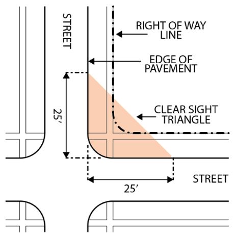
D. Sight Triangles
1. Intersections and Corner Lots
At intersecting streets, a sight triangle shall be established. The sight triangle shall be formed by connecting two points along the pavement edges or the extended lines of the pavement edges, 25 feet from where those extended lines meet.
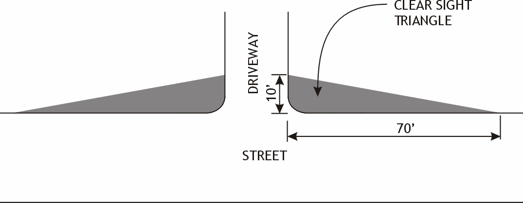
2. Driveways
For any driveway, a sight triangle measuring ten feet from the back of curb and extending 70 feet from the edge of each side of the driveway shall be required.
3. Design Standards
Within the sight triangle, no materials which would impede traffic visibility shall be allowed. Structures, fences and plant materials that extend into the sight triangle between two and one half feet and eight feet in height, as measured from the grade of the street or drive, shall not be allowed.
4. Alternative Dimensions
Alternative dimensions shall be approved by the City Transportation Director or designee if the proposed dimensions will function as adequately as or better than standard Ordinance dimensions. The alternative dimensions shall be sealed by a qualified design professional, and designed utilizing the following criteria based upon industry standards such as, but not limited to, A Policy on Geometric Design of Highways and Streets by the American Association of State Highway and Transportation Officials (commonly known as the AASHTO green book); Traffic Engineering Handbook by the Institute of Transportation Engineers; or Roundabouts: An Informational Guide by the U.S. Department of Transportation Federal Highway Administration.
a. Street width;
b. Posted speed limits;
c. Stopping position;
d. Field obstructions;
e. Horizontal and vertical curves;
f. Travel direction (one-way vs. two-way streets); and
g. Traffic control measures (signals, roundabouts, etc.).
E. Cul-de-sac Streets
Cul-de-sac streets shall not be longer than 800 feet and shall be terminated by a circular right-of-way having a minimum diameter of 92 feet or an approved alternative turnaround as determined by the City Transportation Director or NCDOT, or appropriate designees. The length of cul-de-sac streets shall be measured from the centerline of the bulb to the edge of pavement at the nearest intersection.
F. Stub Outs
1. Unless exempted below, stub outs shall be required on each side (as defined by each of the cardinal directions) of a development as follows:
Lineal Stub Out Requirement (Feet) | Applicable Zoning Districts |
|---|---|
At least one stub out for every 650 linear feet on any single side of a proposed development | RU-M, RC (20 max); RS-M(D) (18 max); PDR (above 8,000); CSD; MU; CD; DD; CI; CN |
At least one stub out for every 1,000 linear feet on any single side of a proposed development | RU-5 (8 max); RS-M (8 max); RS-8 (5 max); PDR (below 8); OI; CG; CC |
At least one stub out for every 1,000 linear feet on any single side of a proposed development |
2. Stub outs shall not be required if:
a. Adjacent existing development has not made any accommodation for such connections; or
b. Adjacent sites are permanently protected from development through conservation easements or ownership that precludes development; or
c. The only point of access would require crossing floodplains, steep slopes, or other similar natural features; or
d. The existing street pattern in the area of the proposed development already provides for vehicular connections at intervals no greater than one-half mile apart in the Rural Tier, one-quarter mile apart in the Suburban Tier, or one-fifth mile apart in the Urban Tier.
3. Connections
The proposed street layout in new development shall be coordinated with the existing street system with connections made at all stub outs. Stub outs shall be built to the edge of the site.
a. Alternatives to building to the edge of the site are allowed per the following:
(1) A determination is made by NCDEQ that prevents the full construction of the stub, in which case the stub shall be constructed to the extent allowed by NCDEQ. The following shall also be required:
(a) A payment-in-lieu for the remainder of the stub out shall be provided pursuant to the requirements of the City’s Reference Guide for Development.
(b) Construction and slope easements, and the right-of-way required to build the stub out, shall be dedicated.
(2) Any other request to modify this requirement will require a variance for the minimum modification necessary to provide relief, per Sec. 3.16, Variance. If a variance is approved, the following shall also be required:
(a) A payment in lieu of construction shall be required pursuant to the requirements of the City’s Reference Guide for Development.
(b) Construction and slope easements, and the right-of-way required to build the stub out, shall be dedicated.
b. Where no full connection can be made as a result of the topography of the site being developed, the developer shall install a cul-de-sac bulb or other turnout facility at the stub out constructed according to the City of Durham Reference Guide for Development.
4. Street Connection Notice Sign
A four-square-foot sign that reads “Future Street Connection” shall be placed at the center of the terminus of the street stub, facing oncoming traffic, and measuring five to six feet in height from the ground. The sign shall comply with any applicable City of Durham Department of Transportation, NCDOT, and MUTCD standards.
G. Alleys
Alleys shall be permitted and designed in accordance with design criteria established by the City or NCDOT, as applicable.
H. Reserve Strips Controlling Access
The reservation of private property strips of too narrow a depth to permit development as a means of controlling access to public ways shall not be permitted.
I. Frontage Roads and Access Streets
Where a development abuts or contains a controlled or limited access right-of-way, whether existing or proposed, an access street or frontage road shall be required.